

Sorted by date Results 1 - 16 of 16
At a Glance Length: There are three trail options: Crystal Lake North Trail #351 (2.3 miles one way), Trail South #351 (4.4 miles one way) and Lindbergh Trail #490 (2.8 miles one way from the head of Lindbergh Lake) that includes a four-mile boat trip to the head of Lindbergh Lake. Day hike or overnight backpack experience. Elevation gain: Crystal Lake sits just over 4,800 feet. Crystal Lake North Trail #351 starts at 5,770 feet; Crystal Lake South Trail #351 starts at 5,080 feet and Lindbergh... Full story
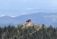
Directions: Drive north on Highway 83 approximately 28 miles from Seeley Lake, or two miles south of Condon (mile marker 39). Turn east onto Rumble Creek Road. Follow the road four miles to the parking area, just past the Cooney Lookout. Elevation: 5,633 foot gain (9,356 total) Distance: Five miles to the peak Difficulty: Advanced Disclaimer: This trail is not a US Forest Service trail and some sections of the trail can change or become hazardous. The hike Holland Peak is truly a must hike for... Full story
Length: 7 miles (5.5 to Upper Holland, 1.5 to Sapphire) 14 miles roundtrip Elevation gain: 3,100 feet (2,100 to Upper Holland, 1,000 to Sapphire) Services: The trailhead is located near Holland Lake Lodge and has a large parking lot as well as a pit toilet. Lot is mainly used for the Holland Falls trail (416) Directions: Turn east off Highway 83 near mile marker 35 onto Holland Lake Road. Stay to the left at all road junctions. After passing the Day Use Area and Campground, the road comes to a... Full story
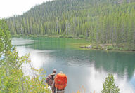
Distance: 4.3 miles (8.6 miles roundtrip) Difficulty: Moderate. Elevation gain: 1,368 feet Services: The trailhead has a relatively large parking lot with a pit toilet. No drinking water is available at the trailhead. The trail sees heavy use. Foot travel and horses are allowed. Directions: On Montana Highway 83, turn west onto Kraft Creek Road at mile marker 37 (just south of Condon). Follow Forest Service Road 561 for about 11.5 miles to the trailhead. The trailhead to Heart and Crescent Lake... Full story
At A Glance Length: Approximately 1.6 miles one way, 3.2 miles round trip Elevation gain: 425 feet Usage: The trail is primarily used by day hikers and backpackers. Note: There is no overnight camping at Glacier Lake. Services: The trailhead has a relatively large parking lot with a pit toilet. No drinking water is available at the trailhead. Hikers are able to bring their dogs on the trail. Directions: Travel along Montana Highway 83. Turn west onto Kraft Creek Road at mile marker 37 (just... Full story
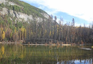
SEELEY LAKE – "It's beautiful," said two hikers who were heading back to the Morrell Falls trailhead the afternoon of Oct. 19. The hike into Morrell Falls has been forever changed following the Rice Ridge Fire burning through the entire 2.7-mile trail. Hikers have the opportunity to see areas of high intensity fire where all the crowns were consumed to areas that the fire left untouched and everything in between. Despite the best efforts of the Seeley Lake Ranger District to keep the trail c...
Directions: Turn north off Highway 200 East onto Gold Creek Road No. 126 near Potomac. Take next left up unmarked Twin Creek Road No. 2117. Stay on main road until trailhead. Total time to trailhead parking is one hour by truck and one hour, 20 minutes with a horse trailer. To access trail No. 505, go past the trailhead to the right and left up the small rocky slope where trail 505 begins. This is also the trail to the junction of trail No. 513 to Shoofly Meadows. From this trail sign it is... Full story
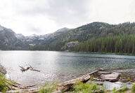
At A Glance Length: Trailhead to the Lake - 0.25 miles. Well-established trail around the lake, 1.9 miles. Elevation: Trailhead: 4,950 feet; Lake: 4,800 feet Directions: Turn east off Highway 83 onto the Morrell-Clearwater Road north of Seeley Lake. Drive three miles and take a left at the US Forest Service Road #4270 Clearwater Lake Loop Road. Follow for another three miles to the trailhead. Since the road is a loop, continue from the trailhead to the north seven miles until reaching Highway... Full story
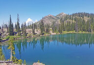
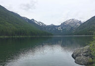
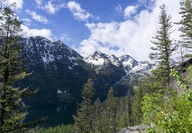
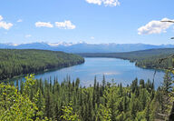
At A Glance Pyramid Pass, Lake and Peak Length: 5.2 miles from the parking lot to Pyramid Pass and the Bob Marshall Wilderness Boundary. 0.75 miles further to Pyramid lake, 1.5 miles up to Pyramid Peak **The sign in the parking lot is wrong- it shows 4 miles to the pass** Elevation: Trailhead: 5,200 feet; Pass: 6,695 feet; Lake: 6,946 feet, Peak: 8,309 feet Directions: Turn east off Highway 83 onto Morrell Creek Road north of Seeley Lake. Drive just over a mile before taking a left, following... Full story
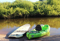
At a Glace Length: 3.5 mile long river trail, 1.5 mile return hike to start Directions: From Seeley Lake, drive four miles north on Highway 83. Turn left at the Clearwater Canoe Trail sign and drive 0.5 miles to the put-in. The canoe takeout and start of the return hike is at the Seeley Lake Ranger Station. Difficulty: Very easy- All ages Overview: At the put-in there is room for about six vehicles and there is a pit toilet. The put-in starts you off in a bend of the river with virtually no... Full story
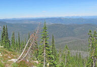
SEELEY LAKE - On a Tuesday afternoon, June 6, I set out for my first real adventure since moving to Seeley Lake. After a few weeks of running around town with the Morrell Mountain looming as a backdrop, I decided I needed to see the view from the top. I wanted to make it an all day activity, so I grabbed a bike and headed off towards the mountain. From Seeley Lake, it was a fairly easy eight-mile ride to Morrell Mountain road. Although I haven't been on a bike in a few months, I got to the base... Full story
Length: Approximately 4.5 miles one way Elevation: 6,374 feet at Fly Lake Usage: No stock, no bikes or motorized vehicles. Trail not completely cleared. Services: Parking at trailhead one hour from Hwy 200. Directions: Turn north off Highway 200 East onto Gold Creek Road near Potomac. Stay on main road heading toward the Gold Creek trailhead. Near mile marker 12, turn right heading five miles to the trailhead parking. Total time to trailhead parking is about a one hour drive from Highway 200.... Full story
Directions: Turn east off Highway 83 near mile marker 35 onto Holland Lake Road. Stay to the left at all road junctions. After passing the Day Use Area and Campground, the road comes to a dead end at the trailhead, about four miles from the highway. Length: 1.6 miles one way Elevation: Trailhead: 4,050 feet; Falls: 4,800 feet. Usage: Heavy: Hiking. No motorized, stock or mountain biking. Services: Parking and vault toilet at trailhead. Holland Lake Campground and Day Use Area is just down the... Full story
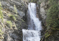
Length: 2.7 miles one way Elevation: Trailhead: 4,730 feet; Falls: 4,840 feet; Highest Point: 4,880 feet Usage: Heavy: Hiking, mountain biking and horseback riding allowed. No motorized use except with snowmobile after Dec. 1. Services: Parking, Vault toilet at trailhead and several dispersed, undeveloped campsites. No developed drinking water. Directions: Head north on Highway 83 from Seeley Lake 0.5 miles. Turn east (right) onto Morrell Creek Road just north of the Seeley Lake Veterans... Full story
Length: 2 to 3 miles to Lower Rumble Creek Lake and another 1/2 mile to a mile to Upper Rumble Creek Lake. Distance varies with route. Elevation: Trailhead at 4,800 feet; Lower Rumble Creek Lake - 7,000 feet; Upper Rumble Creek Lake - 7,900 feet; Holland Peak - 9,356 feet Directions to the Trailhead for East Foothills Trail No. 192: Approximately 28 miles north of Seeley Lake or two miles south of Condon, at mile marker 39, turn east on the Rumble Creek Road across from Condon Community Church.... Full story
Length: 2 miles one way Elevation: Lake Elsina – 6,320 feet; Pass – 6,680 feet; Lake Dinah – 6,480 feet. Directions: To arrive at the trailhead at Lake Elsina, follow Montana Highway 83 to mile marker 19.5. Turn west on Boy Scout Road and go about one mile. Turn north on Fawn Creek Road No. 4349. Stay left on Road No. 4349 about a mile from Boy Scout road and across from the heliport and large parking area. Continue on Forest Road No. 4349 for another 4.5 miles, following signs to Lake Elsin... Full story


