
Part 3 of 3
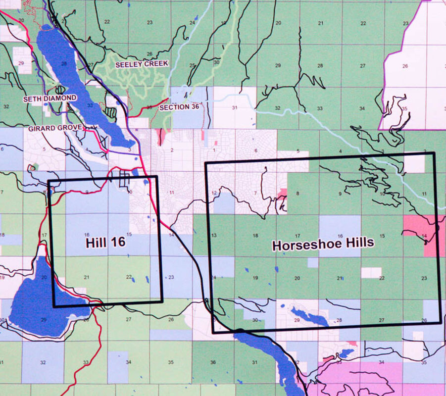
The Hill 16 and Horseshoe Hills project areas.
SEELEY LAKE – Part I of the report on the March 7, 2018 public trails meeting gave the results of the resident and visitor survey conducted in 2017 by the Clearwater Resource Council (CRC) Trail Advisory Council. Part II presented the views of local business owners and a discussion on partnerships between land managing organizations and special interest user groups. Part III presents the Trail Advisory Council's recommendations derived from the surveys, as well as suggestions for how to proceed in the future.
Taking into consideration which recreational usages had the most impact on the economy of Seeley Lake, those trails the community members indicated as most important to them and the desire for expansion of the existing trail system, the Trail Advisory Council came up with a number of recommendations. CRC president Jon Haufler organized them into three divisions.
Winter Trails: Between the Nordic ski trail system and the Seeley Lake Driftriders snowmobile trail system, the area winter trails were considered to already meet the general needs of the community.
Summer Motorized Trails: Though there are already a number of roads available, the Advisory Council felt there were opportunities for establishing better loop systems and for identifying and mapping loop drives for people unfamiliar with the area. An on-going project that Seeley Lake resident Ron Cox and others are working on is the creation of an ATV trail connecting Seeley-Swan High School to Cottonwoods Lake Road. Haufler also reported that Fish Wildlife & Parks and The Nature Conservancy are willing to look at the possibility of a North Fork route, creating a loop around the Fawn Creek area. At the south end of town, TNC is working with ATV members to identify a loop route from Vaughan Creek Road (also known as Spook Lake Road) to Blanchard Road. This would entail creating two short road sections to connect with roads that are already in place.
Summer Non-Motorized Trails: Popular existing trails such as those to Morrell Falls, Lake Dinah, Seth Diamond and the Girard Grove require only maintenance work, though thought is being given to providing a handicap accessible trail to the big western larch in the Girard Grove. Trail 30, popular with mountain bikers, runs through the Rice Ridge burn area and probably will require extensive rehabilitation.
Trails to Crescent Lake and Crescent Mountain exist but are not generally well know. Providing better signage and disseminating more information could make those trails more popular.
Also needing better mapping and signage is the Seeley Lake portion of the Great Divide Mountain Bike Route which annually brings mountain bikers from all over the world. Andy Bauer reported Adventure Cycling, which originally created the trail, is working on a map connecting the route to their headquarters in Missoula. The proposed route follows existing roads passing through TNC, US Forest Service, Bureau of Land Management and Montana Department of Natural Resources and Conservation lands and goes from Seeley Lake to Placid Lake State Park, up Vaughn Creek Road to Belmont Ridge, Belmont Creek, Cow Creek, Gold Creek then over Sheep Mountain divide to the Rattlesnake to Missoula. Adventure Cycling expects that maps will be ready for sale in June of 2018.
Sunday Mountain has a trail but not a full trail system. The Seeley Lake Ranger District has expressed a willingness to create new trails in that area if partners and volunteers are willing to help with the project.
Projects already in progress include the trail around Seeley Lake and walking trails from town to Double Arrow Lodge and Big Larch Campgrounds. Parts of the lake loop trail are available now; other sections still need to be completed. The Double Arrow trail to town is scheduled to be established in conjunction with upcoming Highway 83 improvements. Five Valleys Land Trust is currently working on establishing a trail from Big Larch to town.
Further Trail Planning Areas: The Trails Advisory Council identified two areas for possible extensive trail development.
Hill 16 – Located southwest of town around the Lake Placid area, these are Department of Nature Resource and Conservation lands with TNC lands surrounding them. Currently there are a series of old roads throughout. Though closed off now, the roads potentially offer opportunities for motorized usage. There is also room in the Hill 16 area for hiking, horseback riding, mountain biking and other usage. DNRC cannot develop the area on its own, but they are willing to entertain proposals for trails from interested groups.
Horseshoe Hills – Haufler said the Horseshoe Hills area west of Salmon Lake offers the best opportunity for the development of new trails. He said a lot of people already use existing trails in the area, even though it is not a formally designated trail system. Several of the 52 recommended new trails named on the community survey are in the Horseshoe Hills area. Haufler said there is a definite need to take a closer look at what trails are already out there and to identify what might make a good trail system there. Such an undertaking would be a long-term process and entail numerous reviews, but he said land managers in the area are receptive to proposals.
John Stegmaier from Missoula County Parks and Trail Bond said his organization has money available specifically for building any kind of new trails. The main requirements are 1) the trail group needs to have secured permission from the land manager; 2) the group needs to have a complete or at least a partial plan that assures the funding will be used for something realistic and capable of being implemented; 3) the group must contribute 80 percent of the money and Parks and Trails will contribute the other 20 percent.
Bill Wall's final presentation reiterated CRC's role as a non-voting facilitator of the trails project. Having gathered information from the community, collated it, reported back to the community and recommended where and how to proceed, CRC considers its part and the planning phase of the project complete. All reports and maps related to the process will be available on the CRC website.
Next comes the implementation phase and Wall said that work needs to be carried out by the community in collaboration with interested and involved partners.
Wall said, "If we're going to keep this thing going, we need folks who are interested in trails and passionate about their uses of trails."
He said those folks need to come forward and get engaged with the Advisory Council to make things happen. The Advisory Board is composed of representatives from user groups (e.g., hikers, mountain bikers, snowmobilers etc.), representatives from land managing agencies and anyone interested in improving and expanding recreational opportunities in Seeley Lake. No longer a sub-group of CRC, the Trail Advisory Council will now become its own self-governing body.


Reader Comments(0)