
From 160,000 to 4,800 acres
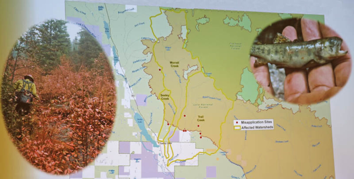
Retardant misapplication occurs when it is dropped within 300 feet of a stream channel or waterway. There were six misapplications in the Trail Creek watershed (outlined in yellow), one in the Seeley Creek watershed and one in Florence Lake. The Seeley Creek and Trail Creek watersheds were eliminated from possible salvage to avoid compounding the effects.
For a full map of the project & more information visit https://www.fs.usda.gov/project/?project=53114
SEELEY LAKE – A handful of interested community members gathered Jan. 10 to learn more about the less than 5,000 acres proposed for timber salvage on the 160,000-acre Rice Ridge Fire that burned last summer. Seeley Lake District Ranger Rachel Feigley and nearly 20 U.S. Forest Service employees on the Interdisciplinary (ID) Team explained how they determined what areas could be cut and what areas they plan to plant. Comments will be accepted until Jan. 22 at 5 p.m.
Remote Sensing Coordinator Steve Brown explained how they determined the number of acres that could be opened for salvage on the Rice Ridge Fire based on three management considerations.
The first step determined exclusion areas including: land not owned by the Lolo National Forest, wilderness areas, wilderness study areas, inventoried roadless area and riparian habitat conservation area. This reduced the area burned to 31,000 available acres for salvage.
Accessibility was the next factor since the region determined that no new roads could be built for the salvage project. This limited the area available to salvage to within 1,500 feet of an existing road and slopes less than 35 percent.
The final consideration was economic viability. The minimum volume and size was defined as greater than or equal to 5,000 board feet per acre for tractor yarding and 8,000 board feet per acres for skyline yarding with an average size of 10 inches or more in diameter. This final criteria reduced the area to 5,947 acres.
With the remaining 5,947 acres, the region used design criteria that further limited the area available for salvage harvest based on ecological constraints for the proposed harvest. This included areas of habitat for listed species including lynx and bull trout and watersheds where retardant was dropped within 300 feet of the stream channel.
Feigley said that areas where lynx may exist and where it is designated lynx critical habitat were excluded from salvage opportunity. This was an effort to comply with the Northern Rockies Lynx Management Direction and to avoid additional adverse effects to lynx habitat.
In areas of moderate and high burn severity where the understory was consumed, the lynx will not likely be present since the habitat for their primary food source, the snowshoe hare, is gone. These areas were no longer considered suitable for lynx and the team does not feel that additional work would further impact the lynx.
Retardant misapplication was another design criteria that eliminated the Seeley and Trail Creek watersheds from salvage harvest. According to the 2011 mandatory national direction specific to protecting species including cutthroat and bull trout, a 300-foot setback on either side of the waterway was required for all retardant application unless being used to protect life and safety.
"In the case of Seeley Lake, we did have the need to use retardant a few times and it did result in misapplication," said Feigley.
Misapplication sites included around Florence Lake, six sites along Trail Creek and Seeley Creek.
"You can see the retardant worked but you can see that it did kill the shrubbery and we also found some fish mortality in those locations," said Feigley. "From the 5,900 acres, the misapplication did take away some opportunity in Trail Creek and Seeley Creek watersheds and that is part of looking at the long term impacts to those watersheds and the effects to fish and watersheds should we do some additional work in there."
Feigley said that while Morrell Creek did not have any fish mortality, they want to minimize the activity because Trail Creek flows into Morrell Creek and they are connected watersheds.
"We are still looking at doing some winter logging in [the Morrell Creek drainage] and some limited timber road construction," said Feigley.
Fisheries biologist Shane Hendrickson said that the severity of the retardant misapplication sites varied.
In Trail Creek there was one confirmed fish kill and one suspected but that was not confirmed due to the intensity of the fire at the time. There were six hits in the watershed. "It is the cumulative nature of all six of those within the watershed [that is the concern]," said Hendrickson.
In Seeley Creek the retardant hit was substantial.
"The air tanker aligned with the stream and it was a half mile long drop on the stream," said Hendrickson. "We killed roughly a half mile of that stream."
With the design criteria applied, the proposed salvage opportunity totals 4,838 acres. This includes the use of 116 miles of existing roads, 16 miles of reconstructing of existing road prisms and 16 miles of temporary road construction.
Many of the existing roads also double as snowmobile trails in the winter. Winter recreation could be impacted depending on the timber sale specifications and haul requirements.
"Ultimately [Forest Service employees] are working really hard to accomplish this and the last thing we want to do is work really hard and not see it be successful," said Brown. "While we recognize that it may limit some of the opportunity in terms of getting timber, it will more than likely in the end mean that we are successful in getting something."
In addition to timber salvage, 11,533 acres of the fire are proposed for planting. This is a National Forest Management Act requirement to reforest areas to sustain forested conditions over time and "it is also the right thing to do," said Feigley.
Feigley said they used maps of soil burn severity and overstory vegetation mortality in their assessment to help determine the value of the wood, potential for vegetation recovery and reforestation need.
"[Where planting would occur] also had a lot to do with is there an adjacent seed source, what was the nature of the species within those, what would be a more desirable species and what can we do to try to turn it in the direction that we want to see long term," said Feigley.
The final action in the project is to reduce hazard trees.
"It is not only a matter or public safety but it will also save us a lot of work in the near term because those trees are going to be coming down anyway," said Feigley.
Hazard trees will be identified by specific requirements including percent lean and percent char. This work will be done with machinery and include merchantable and non-merchantable timber.
Public scoping ends Jan. 22. The District expects to ask for the Emergency Situation Determination from the chief of the Forest Service in March because of the urgency to salvage wood products and accomplish other project goals that are directly related to resource restoration or protection. This reduces the ability for the public to object.
Providing the ESD is granted, the start of the environmental assessment comment period and draft decision release is scheduled for May and June. Feigley said they will consider hosting another public meeting depending on interest. The hope is to have the decision notice completed by August so implementation can begin in August and September.
For a full map of the project and more information visit https://www.fs.usda.gov/project/?project=53114


Reader Comments(0)