
A Place for All
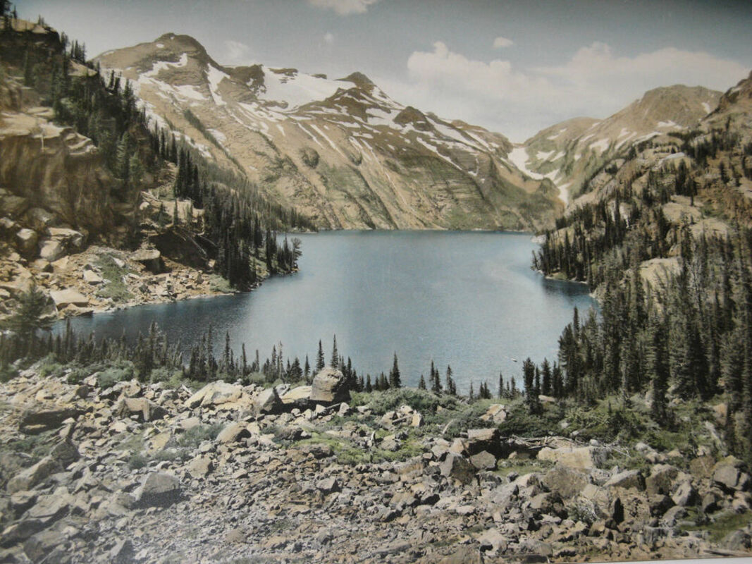
Turquoise Lake with Mt Shoemaker upper left and Sunrise Glacier in upper center.
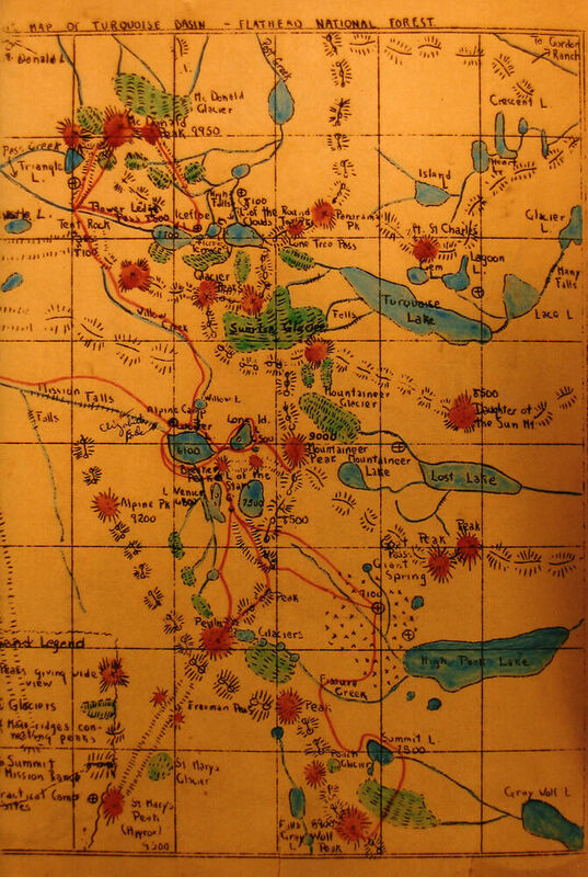
Shoemaker Sketch Map. 1927.
If you were to look at a map of the Mission Mountains 100 years ago, you would see a lot of blank space. Except for verbal descriptions and sketches shared by the early-day Native people, priests, trappers, hunters, and prospectors, the Mission Mountains were, for the most part, uncharted at that time. McDonald Peak was one of the few mountains named on the early maps. Most of the mountains, lakes, streams, and other features were not shown.
Many of the place names on the present-day maps of the Mission Mountains came from the efforts of Theodore Shoemaker, Asahel Curtis, and the Montana Mountaineer's exploratory trips into the Mission Mountains.
Sponsored by the Northern Pacific Railway Company, Theodore Shoemaker and Jack Clack, Forest Service employees, led a group of photographers and writers into the Mission Mountains during the summer of 1922.
The objective of the exploratory trip was to scout the area for future tourism promotion. While exploring the remote area, they named a multitude of lakes and mountains.
In 1923, Shoemaker helped found the outdoor club, the Montana Mountaineers, who also take credit for place names seen on today's maps. Beginning in 1923 and continuing through 1928, Shoemaker led the Montana Mountaineers on additional exploratory trips into the Mission Mountains naming additional peaks, lakes, and other natural features. Based on information from these trips, Shoemaker produced the 1923 and 1927 sketch maps and helped produce the 1923 USFS map titled "Turquoise Basin – Flathead National Forest."
The following is a small sample of the many names bestowed on the landscape:
Panoramic Peak 8400'
Theodore Shoemaker named Panoramic Peak on the 1922 exploratory trip. According to Shoemaker, it was so named "....because of its superlative view." Originally, the peak at 8650' was named Panoramic Peak and the peak to the west (8400') was Round Top Peak. Modern maps show Panoramic Peak at the Round Top Peak location.
Based on personal experience, I think that Shoemaker had it correct – peak 8650' is the true Panoramic Peak.
Sunrise Glacier
The renowned photographer Asahel Curtis was credited with naming Sunrise Glacier while on the 1922 exploratory trip. Theodore Shoemaker wrote, "Every morning the sun glints from the big glacier which hangs under Glacier Peaks long before it shines on the lower points, and so we called it Sunrise Glacier."
Turquoise Lake 6424'
Photographer Asahel Curtis also named Turquoise Lake while on the 1922 exploratory trip. Shoemaker noted: "Because it looked like nothing so much as a great mass of turquoise stone melted and run into its basin by the heat of some hidden fire, we named this largest of the upper lakes Turquoise Lake."
Daughter of the Sun Mountain 8777'
According to Theodore Shoemaker, Daughter of the Sun Mountain was a translation of an Indian word. This mountain was given this name because it was the first point to receive the sun in the morning and the last to lose the sun in the evening. Asahel Curtis was credited with naming this mountain.
The first recorded ascent of this peak was in 1923 by two members of the Montana Mountaineers, Charles Watson and Freeman Daughters. In 1927 the A.C. Tate climbing party, which included Tate and his son Mac, as well as local outfitter Cap Laird and wrangler Babe Wilhelm made the second recorded ascent of the peak.
Not knowing of the 1923 ascent, Tate published an article afterward mistakenly stating that his party was the first to summit the mountain.
Lace Lake 6333'
Theodore Shoemaker named the present-day Lace Lake on the 1922 exploratory trip. The lake reflected the vertical and horizontal fissures on the adjacent cliffs, reminding Shoemaker of fine lace. He wrote: "Tree fringed and exquisite, surrounded by rugged peaks and glaciated rocks lies Lace Lake, with blue-green waters reflecting the delicate tracery which inspired its name."
Evidence suggests that in the late 1910s, both locals and early survey crews used the name Lace Lake when referring to nearby Turquoise Lake. Some residents thought that the numerous waterfalls and cascades flowing from the snowfields at Turquoise Lake produced a lace-like pattern. An old 1919 photo of this lake is captioned as follows:
"Now 'Turquoise' or earlier 'Lace Lake' . . . 8-27-1919. Photo by C.K. Should be Lace Lake. We called it by both names in 1919. Swan, K.D., is wrong in saying his wife and others gave it a name (Turquoise)- much later – 1924. We were there much earlier - 6 years - and not the first ones. Lace is the better one. 'Lacy streams from the glaciers.'"
Lake of the Clouds 7760'
Theodore Shoemaker credits Asahel Curtis for naming Lake of the Clouds on the 1922 exploratory trip. Shoemaker stated, "Clear on the summit of the Missions, with glaciers hanging over one edge and the other side fringed with trees, we found this Lake of the Clouds, and so named it because cloud ghosts seemed always moving just beneath its surface". This lake is within the Grizzly Bear Conservation Zone, an area closed to humans from July 15 to October 1 each year due to the high concentration of grizzly bears in this area.
Giant Spring
The Montana Mountaineers, led by Theodore Shoemaker on the exploratory trip into this area, named Giant Spring. Water from this spring eventually flows into High Park Lake. The Giant Springs is not located where the present-day maps have it marked on the map. It is approximately ¾ mile north in the next drainage.
Lake of the Stars 7600'
Theodore Shoemaker named Lake of the Stars on the 1922 exploratory trip. It was so named because, when looking down at it from the above ridge, the sun's reflection on the water's ripples sent flashes like twinkling stars.
To honor Theodore Shoemaker, in 1960 the US Forest Service named the 8644' peak in the Mission Mountains Mount Shoemaker, though many of today's maps have Mount Shoemaker in the wrong location.


Reader Comments(0)