
Part I of II
SEELEY LAKE – In 2014 Clearwater Resource Council (CRC) launched an examination into trail usage in the Seeley Lake area with a view toward developing a comprehensive trails plan. Last year, the CRC Trails Advisory Council designed a survey to better understand the trail-related needs of Seeley Lake residents, visitors and businesses. The results of those surveys were presented March 7 at a public meeting.
Part I presents the results of the resident and visitor surveys. Part II, to be published next week, will report on the survey and interview responses from owners in the business community, recommendations derived from the surveys, and a plan for how to proceed in the future.
CRC President Jon Haufler presented the responses of the 329 residents and visitors who took the survey. Haufler offered some qualifiers about respondents: the majority were over 65 years of age and only five represented the 18-24 age range. In addition, most respondents identified themselves as belonging to a specific group or groups: 43 percent were members of the Montana Wilderness Association; 26 percent the Driftriders Snowmobile Club; 20 percent Seeley Lake ATV Club and 14 percent identified themselves as having special needs or disabilities.
Type of Activities Engaged in the Previous Year: Haufler said the results indicated a "Good, diverse group of recreational users were represented."
Approximately 70 percent of respondents had hiked during the previous year. About 60 percent had engaged in canoeing, kayaking or some form of boating. Cross country skiers came in at about 40 percent, with camping and hunting just below that. Backpacking, photography, riding ATVs and mountain biking was represented at 30-35 percent. Just under 30 percent were snowmobilers and snowshoers. Runners/joggers, horseback riders, orienteers/geocachers and dogsledders were represented by 15 percent or lower of the respondents.
Favorite Recreation Areas: Respondents named 28 different areas, which Haufler considered a "good spread of use areas." Seeley Creek Trails was most used, followed closely by Trail 30/Morrell Creek Area, Lake Marshal and Lake Elsina. Cottonwood Lakes Road, Rice Ridge, Mt. Henry, Lake Alva and Clearwater Lake Trail were also favored places. Approximately 10 percent listed the unfinished trail around Seeley Lake, while nine percent singled out Big Larch Campground. About six-seven percent named Horseshoe Hills, Hill 16 and the Girard Grove, while four percent named the Seth Diamond Trail.
Things Most Liked in Favorite Area: An 80 percent majority cited "scenic" as the reason they liked a given area. Next came wildlife viewing, lack of traffic and the fact the area was nearby. That the trail connected to other places was listed as important to about 35 percent of the respondents. Approximately 35 percent liked a given area because it had challenging trails, while another 30 percent liked their area because it had easy trails. About 25 percent liked their named area because it was dog-friendly or easy to find, another five to 15 percent of respondents listed kid-friendly, good for groups or good for horses as their reasons for liking a trail.
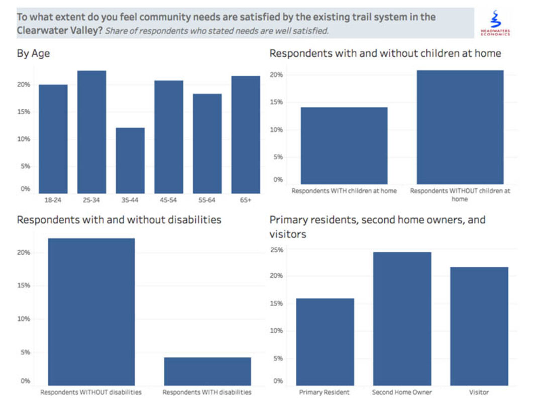
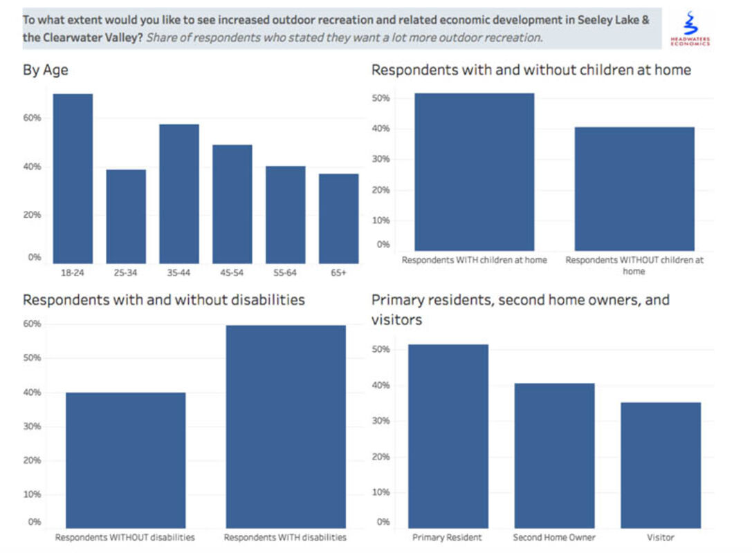
The two survey questions dealing with Community Satisfaction with Existing Trail System and the Desire for Increased Recreation were divided into categories and can best be understood through the graphs (right).
In general, respondents were satisfied with the current trails systems but there was still a desire for more trails. This was especially true among the 35-44 age group and showed even more prominently in the answers of respondents with disabilities and other special needs. Fewer than five percent of that group declared themselves satisfied with the current trails and approximately 60 percent expressed a desire for trails that met their special needs.
Important Features for Great Outdoor Experience: Topping the list was the need to have a trail map posted at the trailhead. Closely following was the desire for the trail to have native or natural surface and to have connections to other places. Loop trails were considered an asset, and directional signage and adequate parking were also considered important. Approximately 18 percent of respondents wanted single-path trails, and the same percentage wanted trail rules and level of difficulty information posted at the trailhead.
The availability of restrooms was important for 15 percent of respondents, while 12 percent wanted trailer parking and garbage disposal availability. Seven percent wanted water available and four percent wanted interpretive signs. Three percent or less of the respondents expressed a desire for corrals and hitching posts, shelters, boardwalks, benches, picnic area, and/or pasture.
Haufler commented that the information would be particularly helpful in making future improvements to trail areas. The survey indicates that rather than put money into creating a picnic area, for instance, time and money would be better spent creating loop trails and ones that connect to other areas.
Reasons for Not Visiting Areas They Would Like to Explore: The largest majority, 60 percent, said though a certain trail or area was on their "want to do" list, they "just hadn't made it yet." Approximately 35 percent of respondents felt they needed to learn more about a given trail before embarking on it. Another 25 percent said their favorite recreational uses were not authorized on trails they wished to explore. About 14 percent elaborated that certain desirable trails were not accessible to people with disabilities. Other reasons given by some respondents: they didn't know how to get to the trail, it was too far away, or other good trails were more readily available.
In addition to the question prompts, the survey also left room for respondents to offer their own suggestions. Though already covered in the body of the survey, some people felt it important to reiterate the need for signage and other markings to help people find and follow the trails.
People also thought it important to stress the need for trail connections between the town and specific trails, between one town and another and between one lake and another. They felt these connection trails should be available to all user types.
Other recommendations were for safe trails around town, the establishment of a single-track mountain bike trail system and an increased number of groomed ski trails. In addition, some people wanted non-road motorized trails, preferably loop trails.
Finally, the survey encouraged respondents to suggest specific trails they would like to see developed. Amidst some general areas, 52 trails were named. These were carefully reviewed by the Trails Advisory Council and classified as highest priority and potentially feasible.
Haufler ended by saying a report containing all the information derived from the surveys, including all 52 recommended trails, would be posted on the CRC website crcmt.org under the "Trails Project" tab.


Reader Comments(0)