
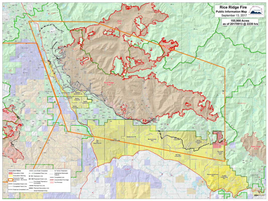
Morning Update: The Rice Ridge Fire grew more than 20,000 acres yesterday. It is now 155,900 acres and 38% contained. There are currently 731 fire personnel assigned to the fire. It has cost $40.1 million.
YESTERDAY: Governor Steve Bullock, Montana National Guard Adjutant General Matthew T. Quinn and the new Chief of the USDA Forest Service, Tony Tooke, met with Incident Commander Greg Poncin and stakeholders at the Incident Command Post yesterday for a briefing on the status of the fire. The Seeley Lake High School LEOs, the youth branch of Lions Club International, served ice cream to firefighters at dinner in fire camp. Doug Janison, part-owner of Houston's Too Catering based in Idaho Falls, Idaho, the contractor providing meals for firefighters at fire camp, presented a $1000 check to the LEOs for their help and as a thank you to the community of Seeley Lake.
Significant fire growth occurred in the interior and the northern part of the fire yesterday in the Bob Marshall Wilderness, but did not threaten fire lines. Forest Road 720 continued to hold as fire backed down towards it near Camp Creek and mop up continued along the fire line from Camp Creek, Findell Creek and Murphy Creek south to Little Shanley Creek on Forest Road 477. The aerial burnout operation taking place the past 3 days on the mountain north of Forest Road 477 between Little Shanley Creek/ Black Canyon Creek on the west and Cave Creek/Dunham Creek on the east (6 miles wide) was almost completed. Following aerial ignition by helicopter yesterday afternoon, the Flathead Hotshots began hand-firing at 7 pm on the shaded fuel break along Road 477 in the area between Little Shanley Creek and Shanley Creek, finishing about 2 am last night. The low intensity burning has successfully met objectives of securing the fire line ahead of the winds associated with the Red Flag Warning this afternoon. Shaded fuel break construction continued east from Forest Road 89 to the west side of Doney Lake, and graders have made it to the North Fork Blackfoot River road (Forest Road 5550) west of Coopers Lake. Helicopters dropped water on the east side of the fire in McDermott Creek canyon to keep the fire from moving south towards Coopers Lake. Structure protection is in place around homes at Coopers Lake and Placid Lake (east of the Liberty fire). Night patrol and mop up focused on fire lines north of Seeley Lake between Camp Creek and Murphy Creek, and along Forest Road 477, with engines supporting the large burnout operation taking place on the south side of the fire. Temperatures in the thermal belt remained above 60 degrees last night, resulting in active fire behavior well into the early morning hours.
TODAY: Winds will be out of the west today at 12 mph, gusting to 22 mph on ridge tops ahead of a cold front approaching the fire area. A Red Flag Warning is in effect from 3 pm until 8 pm for winds gusting to 22 MPH and low relative humidity.
Fire activity is expected to pick up by late afternoon as smoke clears, and smoke columns may develop again today over active parts of the fire. Firefighters will continue to hold and mop up along Forest Road 720 on the northwest corner of the fire as fire backs down towards it near Camp Creek. They will finish the indirect dozer line to the 2015 Richmond Peak fire scar. Mop up and patrol will continue from Camp Creek south and east to Little Shanley Creek near Kozy Korner, including back haul of some hose, pumps and equipment along the fire line where mop up standards have been achieved and the fire line has moved into patrol status. Aerial and hand ignition will be completed on the burnout project where a narrow area between Black Canyon Creek and Dry Cottonwood Creek is all that remains to be finished. Heavy Equipment task forces will continue indirect fire line, shaded fuel break construction, and log and slash removal from Doney Lake east towards Coopers Lake. Structure protection is in place around Coopers Lake and air operations will continue in the McDermott Creek drainage to keep the fire from moving south towards Coopers Lake. Firefighters will coordinate operations with their counterparts on the Park Creek Fire. Structure protection is in place around Placid Lake east of the Liberty fire. Completed*: The suppression strategy for this fire is full suppression on 23% of the fire perimeter and confinement on 12% of the fire perimeter for a total of 35%. The remaining 65% of the fire is burning in remote backcountry and wilderness and will be monitored. Action will be taken as necessary to keep the fire from coming out into areas where values at risk would be impacted. Today's "Completed" percentage in the table on page 1 indicates that 38% of the full suppression and confinement actions taken on the fire have been completed.
Evacuations and Warnings: Powell County evacuation order: includes the Monture Cabin area and the Coopers Lake area. Powell County evacuation warning: includes all other areas of Powell County north of Highway 200 between the Missoula County line on the west and the Lewis and Clark County line on the east and that portion of Zone 5 near Seeley Lake that is in Powell County.
Missoula County evacuation orders and warnings: All Evacuation Zones near Seeley Lake remain under Evacuation Warning. Evacuation/Closure Information: Evacuations and road closures are based upon the need to provide for safety of the public and firefighters, current fire behavior, forecasted weather, and planned suppression operations. Fire officials, Missoula and Powell County Sheriff's Offices, and Montana Department of Transportation will evaluate the evacuation and road closures daily. The Incident Commander and the Missoula and Powell County Sheriffs appreciate your patience and will work hard to get you back into your homes as soon as it is safe to do so. Go to the Missoula County Sheriff's Facebook page or, in Powell County, call 406-396-1386 for the most current information.
Drones and TFR: There is a Temporary Flight Restriction (TFR) for the Rice Ridge fire including "drones" or unmanned aerial vehicles. If drones are detected, air operations stop. If you see a drone in the fire area, including the evacuation areas, report it immediately to 406-813-0527. Your cooperation is needed to insure the safety of our pilots.
Stage II Fire Restrictions are in effect for Missoula and Powell Counties and across the Lolo and Flathead National Forests with the exception of the Bob Marshall Wilderness which is in Stage 1. However, many areas in the wilderness are closed due to the fire. Additional information is on Inciweb and the Lolo and Flathead National Forest websites.
Closures: Multiple closures related to Rice Ridge Fire suppression efforts are in effect for public lands managed by the Lolo and Flathead National Forests, Bureau of Land Management, Montana DNRC, and Montana Fish, Wildlife and Parks.
Visit fwp.mt.gov or call 406-542-5500 for up-to-date information on closures.
Jurisdiction: The Lolo National Forest and the Montana Department of Natural Resources and Conservation (DNRC). Montana National Guard soldiers are providing assistance to the Missoula and Powell County Sheriffs.


Reader Comments(0)