
Rice Ridge Fire Morning Update: The Powell County Sheriff will lift the Evacuation Orders for Coopers Lake and the Sheppy Zone near Monture Cabin in Powell County at 11:30 am today. Both areas will be downgraded to Evacuation Warnings, allowing people to return to their homes.
Upcoming Community Meeting: Ovando: Friday, September 15th, 6 pm at the Ovando Elementary School Gym, 108 Birch Street.
The Rice Ridge Fire acres is still at 155,900 acres due to no IR flight. The containment is 40% with 703 personnel assigned to the fire.
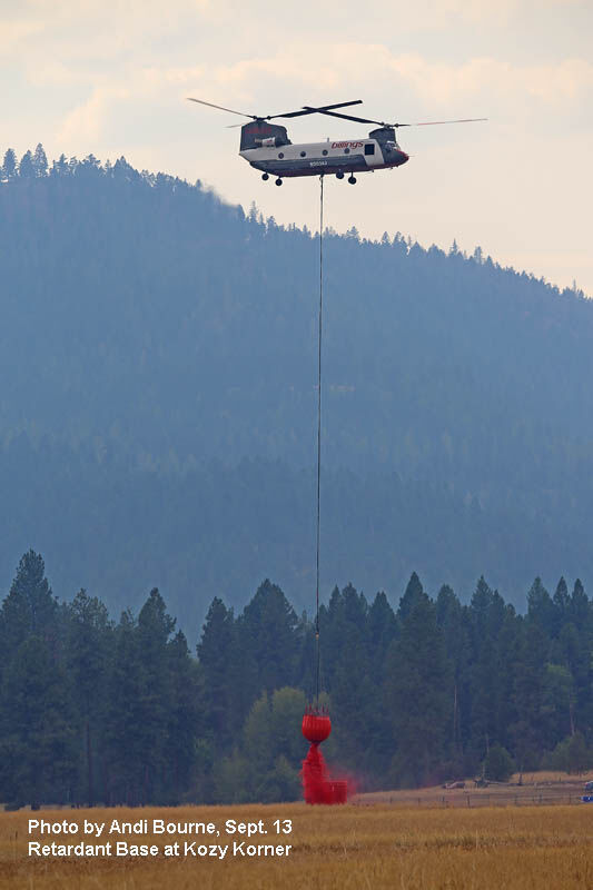
YESTERDAY: Region 8 (including Montana) Federal Emergency Management Agency (FEMA) Director Nancy Dragani and Montana National Guard Adjutant General Matthew Quinn visited the Incident Command Post yesterday afternoon for a briefing and to meet with federal, state and local agencies involved with management of the fire. Thanks to yesterday's cloud cover and cooler temperatures, firefighters were able to build fire line directly on the fire's edge above Forest Road 720 (near Camp Creek) and finally seal off the spot fire in Section 21. The indirect fire line to the 2015 Richmond Peak fire was completed. Mop up, patrol and back haul of excess fire equipment occurred from Camp Creek on the north, to Little Shanley Creek on the east side of the fire. The portable retardant base at Kozy Korner helibase was shut down in anticipation of colder weather. Mop up of the 6 mile burnout between Little Shanley Creek and Cave Creek along Forest Road 477 west of Monture Cabin continued. The Montana National Guard and the Nez Perce Crew rolled approximately 20 miles of hose that was removed from the fire line for shipment back to the Missoula Fire Cache.
Heavy Equipment task forces completed the indirect fire line to Coopers Lake. Removal of logs and slash continued throughout the shaded fuel break areas. Firefighters began removing hose at Coopers Lake and the Double Arrow Subdivision. Structure protection remains in place around Placid Lake (east of the Liberty fire). Precipitation was variable over the fire area with higher amounts on the east side and less rainfall on the west side of the fire. A quarter inch of rain was recorded at Kleinschmidt Flat near Coopers Lake, 7/100 at Morrell Lookout (with some snow) and 11/100 at Seeley Lake overnight.
TODAY: Mop up and patrol will occur from the north side of the fire along Forest Road 720 near Camp Creek south and east along Forest Road 477 to Monture Cabin. Sprinkler systems will remain in place at Blind Canyon Creek and Swamp Creek near Seeley Lake where light rain did not effectively penetrate the tree canopy. Mop up will focus on the area of the burnout between Little Shanley Creek and Cave Creek on the south side of the fire. Log and slash removal will continue along Forest Road 477 and along the indirect line construction. Firefighters will continue back haul of hose, pumps and other firefighting equipment along the fire line where it is no longer needed. Firefighters will continue to dismantle sprinkler systems at Coopers Lake and Double Arrow today, and will begin dismantling the systems at Doney Lake, the Monture Cabin area, and Placid Lake.
Staffed Fire Information Locations: - Seeley Lake at Cory's Valley Market (8 am to 10 am) and Blackfoot Mercantile in Ovando (1 pm to 3 pm).
Completed*: The suppression strategy for this fire is full suppression on 23% of the fire perimeter and confinement on 12 % of the fire perimeter for a total of 35%. The remaining 65% of the fire is burning in remote backcountry and wilderness and will be monitored. Action will be taken as necessary to keep the fire from coming out into areas where values at risk would be impacted. Today's "Completed" percentage in the table on page 1 indicates that 40% of the full suppression and confinement actions taken on the fire have been completed.
Evacuations and Warnings: Powell County evacuation warnings: all Evacuation Zones in Powell County north of Highway 200 between the Missoula County line on the west and the Lewis and Clark County line on the east, and that portion of Zone 5 near Seeley Lake that is in Powell County remain under Evacuation Warning.
Missoula County evacuation warnings: All Evacuation Zones near Seeley Lake remain under Evacuation Warning. Evacuation/Closure Information: Evacuations and road closures are based upon the need to provide for safety of the public and firefighters, current fire behavior, forecasted weather, and planned suppression operations. Fire officials, Missoula and Powell County Sheriff's Offices, and Montana Department of Transportation will evaluate the evacuation and road closures daily. Go to the Missoula County Sheriff's Facebook page or, in Powell County, call 406-396-1386 for the most current information.
Drones and TFR: There is a Temporary Flight Restriction (TFR) for the Rice Ridge fire including "drones" or unmanned aerial vehicles. If drones are detected, air operations stop. If you see a drone in the fire area, including the evacuation areas, report it immediately to 406-813-0527. Your cooperation is needed to insure the safety of our pilots.
Stage II Fire Restrictions are in effect for Missoula and Powell Counties and across the Lolo and Flathead National Forests with the exception of the Bob Marshall Wilderness which is in Stage 1. However, many areas in the wilderness are closed due to the fire. Additional information is on Inciweb and the Lolo and Flathead National Forest websites.
Closures: Multiple closures related to Rice Ridge Fire suppression efforts are in effect for public lands managed by the Lolo and Flathead National Forests, Bureau of Land Management, Montana DNRC, and Montana Fish, Wildlife and Parks.
Visit fwp.mt.gov or call 406-542-5500 for up-to-date information on closures.
Jurisdiction: The Lolo National Forest and the Montana Department of Natural Resources and Conservation (DNRC). Montana National Guard soldiers are providing assistance to the Missoula and Powell County Sheriffs.


Reader Comments(0)