
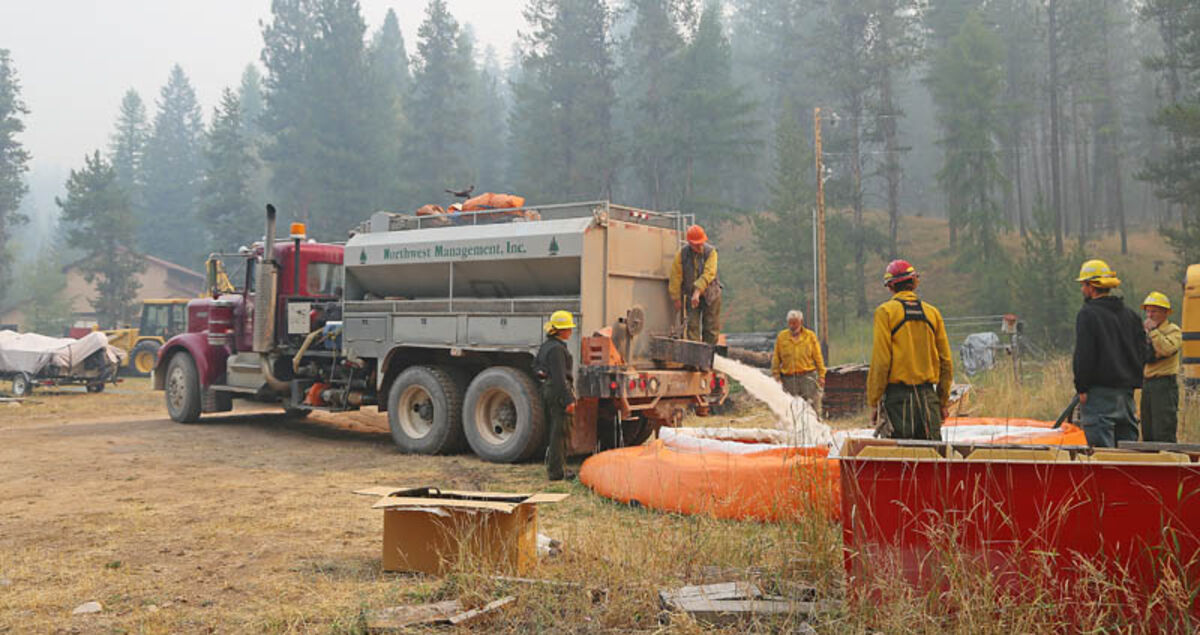
Crews from Idaho and Oregon work on structure protection on the Highway 83 corridor. Every morning they make sure the pumpkins are full, the pump and sprinklers are working correctly. They have found dogs swimming in the pumpkins and a bear got into one on the Double Arrow.
Rice Ridge Fire Morning Update: Community Meeting tonight, Sept. 7 at 6 pm at the Mission Bible Fellowship Church. There will be a meeting Friday Night, Sept. 8 at 6 pm at the Ovando Elementary School Gym.
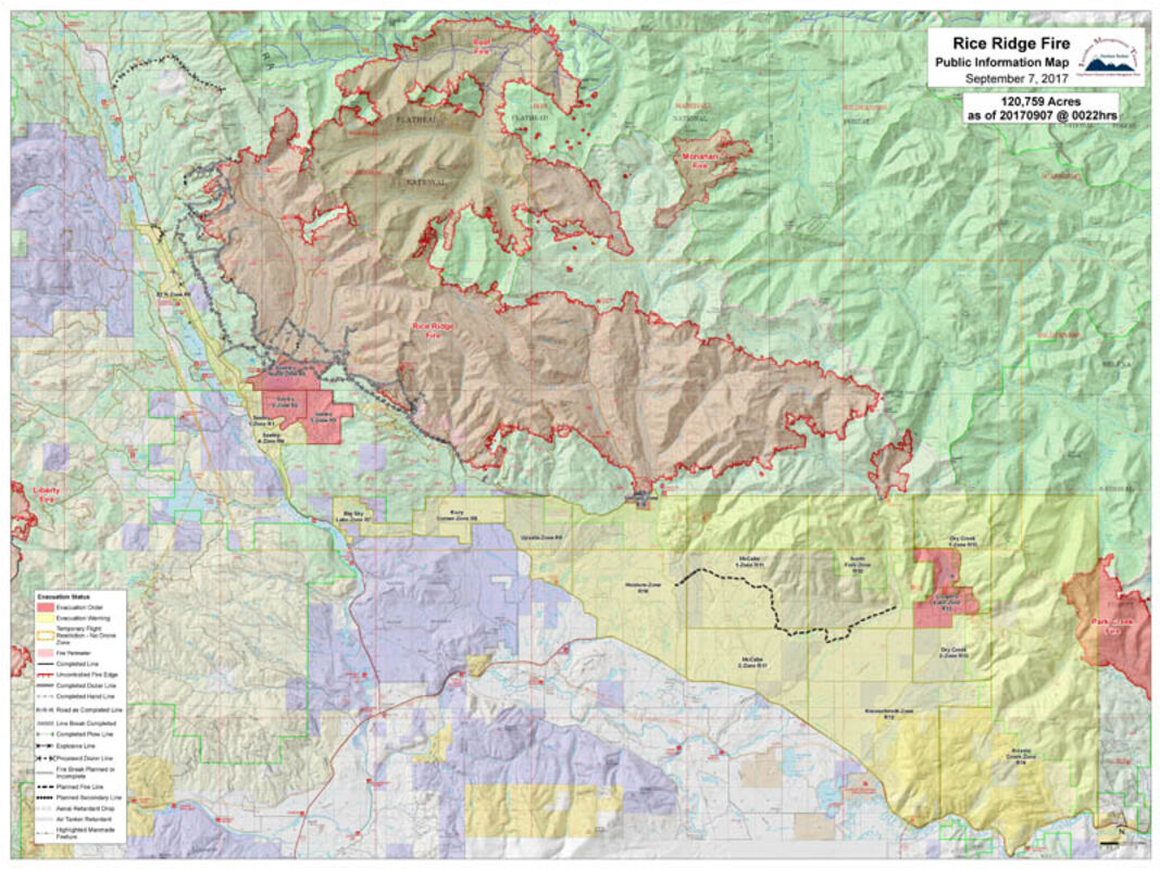
The Rice Ridge fire only added about 1,000 acres yesterday. It is now up to 120,759 acres, is 5% contained and has 725 fire personnel working the fire.
YESTERDAY: The inversion did not lift over the fire area, so no aircraft could be used due to lack of visibility caused by the smoke. However, the shade created by the thick smoke subdued fire activity and allowed firefighters to construct fire line directly on the active fire's edge on the northwest corner of the fire south of Camp Creek. The Flathead Hotshots worked with 2 dozers until 2 am this morning (Thursday) on a particularly troublesome area where they are trying to lock in the northwest corner of the fire. The smoke also allowed firefighters to do mop up on many of the areas along the fire line immediately east of the town of Seeley Lake. Several areas of concern remain along this section of fire line at Findell Creek, Murphy Creek and the spruce bog in Morrell Creek. An excavator being used to remove heavy downfall in the spruce bog area had limited success. Two heavy equipment groups continued to work towards each other between Seeley Lake and Monture Cabin along Forest Road 477, constructing shaded fuel breaks using feller bunchers as they progressed. Mop up continued in the Monture Cabin area and structure protection continued around cabins in the Coopers Lake area. A structure protection specialist began assessments around the Placid Lake area to begin planning in anticipation of any movement of the Liberty fire to the east. Fire managers met with their counterparts from the Park Creek fire to coordinate operations as these fires grow closer together. Due to smoke, firefighters were unable to fly into and wrap the Carmichael Cabin. Night operations continued.
TODAY: The inversion is expected to lift later today, creating increased fire activity as the fire is exposed to more direct sunlight. One area of concern for increased fire activity will be on the northwest corner of the fire where spotting across the line has been a problem. The Flathead Hotshots and the Prescott Hotshots will finish work south of Camp Creek and, working with two dozers, move into the Findell Creek and Murphy Creek drainages north of Seeley Lake. Firefighters will continue to hold, mop up and improve line on the Seeley Lake side of the fire, including the use of a feller buncher in the spruce bog area of Morrell Creek, another area of concern. Shaded fuel break construction using feller bunchers will continue along Forest Service Road 477 towards the Monture Cabin area. Heavy equipment will also be used to link roads to indirect fire line being constructed across private lands south and east from Monture Cabin. Structure protection will continue around Coopers Lake. Firefighters from Seeley Lake Ranger District will try again to be flown in to wrap the Carmichael Cabin in the upper North Fork of the Blackfoot River near McDonnell Meadow northeast of the fire. Firefighters are coordinating heavy equipment fire line construction with the Park Creek fire to the east as these fires grow closer together. Preliminary structure assessment will continue around the Placid Lake area west of Seeley Lake in order to be prepared ahead of time in the event that the Liberty fire tries to move towards that area.
EVACUATIONS & WARNINGS:
Powell County evacuation order: includes the Monture Cabin area and the Coopers Lake area.
Powell County evacuation warning: includes all other areas of Powell County north of Highway 200 between the Missoula County line on the west and the Lewis and Clark County line on the east.
Missoula County evacuation orders and warnings:
All Orders and Warnings in Missoula County remain in effect.
Missoula County residents can receive emergency notifications of critical alerts via their choice of text, phone and/or email by signing up for Smart911 at https://www.smart911.com/. Residents in Powell County can download CodeRED to their mobile devices to receive critical information notifications, available through the Sheriff's website.
FIRE INFORMATION LOCATIONS: Staffed fire information is available in Seeley Lake at Cory's Valley Market (from 8 am to 8 pm) and at the Blackfoot Mercantile in Ovando (from 1 pm to 3 pm).
Firewise: For information on how to improve the chances of your homes and structures surviving a wildfire, visit the Firewise website at http://www.Firewise.org.
Evacuation/Closure Information: Evacuations and road closures are based upon the need to provide for safety of the public and firefighters, current fire behavior, forecasted weather, and planned suppression operations. Fire officials, Missoula and Powell County Sheriff's Offices, and Montana Department of Transportation will evaluate the evacuation and road closures daily. The Incident Commander and the Missoula and Powell County Sheriffs appreciate your patience and will work hard to get you back into your homes as soon as it is safe to do so. Go to the Missoula County Sheriff's Facebook page or, in Powell County, call 406-396-1386 for the most current information.
Drones and TFR: There is a Temporary Flight Restriction (TFR) for the Rice Ridge Fire. The restriction includes "drones" or unmanned aerial vehicles. If drones are detected, air operations stop. "If you fly, we can't! If you see a drone in the fire area, including the evacuation areas, report it immediately to 406-813-0527. Please provide your name, phone number, location and time you observed the drone. Your cooperation is needed to insure the safety of our pilots.
Stage II Fire Restrictions are in effect for Missoula and Powell Counties and across the Lolo and Flathead National Forests with the exception of the Bob Marshall Wilderness which is in Stage 1. However, many areas in the wilderness are closed due to the fire. Additional information is on Inciweb and the Lolo and Flathead National Forest websites.
Closures: Multiple closures related to Rice Ridge Fire suppression efforts are in effect for public lands managed by the Lolo and Flathead National Forests, Bureau of Land Management, Montana DNRC, and Montana Fish, Wildlife and Parks.
The fire is under the jurisdiction of the Lolo National Forest and the Montana Department of Natural Resources (MTDNRC). Montana National Guard soldiers are providing assistance to the Missoula and Powell County Sheriffs' offices in road closures and evacuation programs.
Thanks for the great video of the Chinook working out of Seeley Lake from last weekend, Jeff Cech!


Reader Comments(0)