

Rice Ridge Fire Morning Update: Evacuation Update: From the Missoula County Sheriff – Effective at 8:00 am this morning, the Evacuation Orders for zones 2 and 3 in Seeley Lake have been downgraded to Evacuation Warnings and residents may return home. Zone 5, which includes approximately 6 residences, is the only zone still under Evacuation Order in the Seeley Lake area.
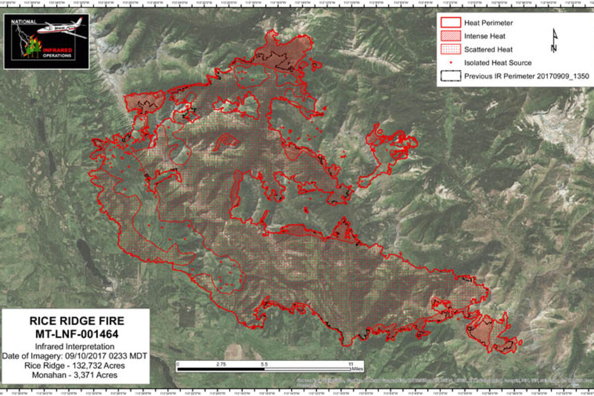
The Rice Ridge Fire grew 10,000 acres in the last two days and is now 132,732 acres. It is 8% contained and has 862 personnel on the fire. The cost is up to $36 million and there are 1719 structures threatened.
YESTERDAY: Yesterday's red flag forecast had crews focused on holding fire line in the northwest corner of the fire, including a 20 acre spot fire ½ mile from the main fire line north of Camp Creek. Fortunately, smoke cleared due to incoming westerly winds, allowing aircraft to assist firefighters on the ground by bringing in water and retardant to support suppression and fire line construction. Dozers built indirect fire line from Forest Road 4363 towards the 2015 Richmond Peak fire scar in case the primary fire line on the 720 road did not hold. Fortunately, the spot fire stayed above Forest Road 720 but continued to back down hill towards the road. Night crews continued monitoring the spot fire as it moved down slope. The fire line held in the Findell Creek and Murphy Creek drainages but more mop up was needed to eliminate concentrations of heat close to the fire line. Firefighters completed installation of sprinkler systems in one of two bog areas in the Morrell Creek drainage and started watering the area. Crews continued mop up on the fire line area directly east of the town of Seeley Lake and the Double Arrow Ranch. Heavy equipment was used to remove logs and slash from the shaded fuel break on Forest Road 477 west of Monture Cabin and mop up continued in the cabin area. Indirect fire line construction continued east of Monture Road (FS 89), with approximately 7 miles of line still to be completed. Helicopter water drops were used to stall the fire's growth on the east side of the North Fork Blackfoot River trailhead to keep fire from crossing McDermott Creek. Firefighters from Seeley Lake Ranger District were flown into the Carmichael Cabin in the upper North Fork of the Blackfoot River near McDonnell Meadow (northeast of the fire), completed wrapping the structure, and were flown out later in the afternoon. Structure protection is completed and sprinkler systems turned on around cabins in the Coopers Lake area. Structure protection was completed on 25 homes on the north side of Placid Lake east of the Liberty fire. Two drone incursions, one on the west side of Seeley Lake and another later in the evening, did not directly affect air operations, but was a violation of the Temporary Flight Restriction (TFR).
TODAY: The northwest corner of the fire remains the highest priority area on the fire due to its location close to the town of Seeley Lake. Firefighters will clear vegetation and downed material upslope of Forest Road 720 where a large spot fire in Section 21 continues to back down to the road which is being used as the fire line. They will also improve Forest Road 4363 and a dozer line to the 2015 Richmond Fire scar as a contingency line in the event that the fire line on Forest Road 720 does not hold. Mop up will continue on fire line in the Findell and Murphy Creek drainages. They will continue installation of a large sprinkler system in a second bog area in the Morrell Creek drainage where they have been having problems with spot fires. Firefighters will continue removing logs and slash from the shaded fuel break west of the Monture Cabin to create defensible space along the fire line in preparation for a planned burnout operation. Heavy Equipment task forces will continue indirect fire line and shaded fuel break construction east of Monture Road. Structure protection on the north side of Placid Lake today will focus on the State Park area as a precautionary measure due to potential for increased fire activity on the Liberty fire.
Staffed Fire Information Locations: Seeley Lake at Cory's Valley Market (8 am to 8 pm) and Blackfoot Mercantile in Ovando (1 pm to 3 pm).
EVACUATIONS AND WARNINGS: Powell County evacuation order: includes the Monture Cabin area and the Coopers Lake area. Powell County evacuation warning: includes all other areas of Powell County north of Highway 200 between the Missoula County line on the west and the Lewis and Clark County line on the east. Powell County residents can download CodeRED to their mobile devices to receive critical information notifications, available through the Sheriff's website.
Missoula County evacuation orders and warnings: Zone 5, which includes approximately 6 homes, is the only zone still under Evacuation Order in Missoula County. All Evacuation Warnings in Missoula County remain in effect.
Missoula County residents can receive emergency notifications of critical alerts via their choice of text, phone and/or email by signing up for Smart911 at https://www.smart911.com/. Evacuation Shelters: Anyone seeking shelter may call the Red Cross of Montana at 1-800-272-6668. Seeley Lake: Camp Paxson at 4200 Boy Scout Road. Ovando: Ovando Elementary School Gymnasium at 108 Birch Street.
EVACUATION/CLOSURE INFORMATION: Evacuations and road closures are based upon the need to provide for safety of the public and firefighters, current fire behavior, forecasted weather, and planned suppression operations. Fire officials, Missoula and Powell County Sheriff's Offices, and Montana Department of Transportation will evaluate the evacuation and road closures daily. The Incident Commander and the Missoula and Powell County Sheriffs appreciate your patience and will work hard to get you back into your homes as soon as it is safe to do so. Go to the Missoula County Sheriff's Facebook page or, in Powell County, call 406-396-1386 for the most current information. Drones and
TFR: There is a Temporary Flight Restriction (TFR) for the Rice Ridge fire including "drones" or unmanned aerial vehicles. If drones are detected, air operations stop. If you see a drone in the fire area, including the evacuation areas, report it immediately to 406-813-0527. Your cooperation is needed to insure the safety of our pilots.
Stage II Fire Restrictions are in effect for Missoula and Powell Counties and across the Lolo and Flathead National Forests with the exception of the Bob Marshall Wilderness which is in Stage 1. However, many areas in the wilderness are closed due to the fire. Additional information is on Inciweb and the Lolo and Flathead National Forest websites.
CLOSURES: Multiple closures related to Rice Ridge Fire suppression efforts are in effect for public lands managed by the Lolo and Flathead National Forests, Bureau of Land Management, Montana DNRC, and Montana Fish, Wildlife and Parks.
Visit fwp.mt.gov or call 406-542-5500 for up-to-date information on closures.
The fire is under the jurisdiction of the Lolo National Forest and the Montana Department of Natural Resources and Conservation (DNRC). Montana National Guard soldiers are providing assistance to the Missoula and Powell County Sheriffs.


Reader Comments(0)