
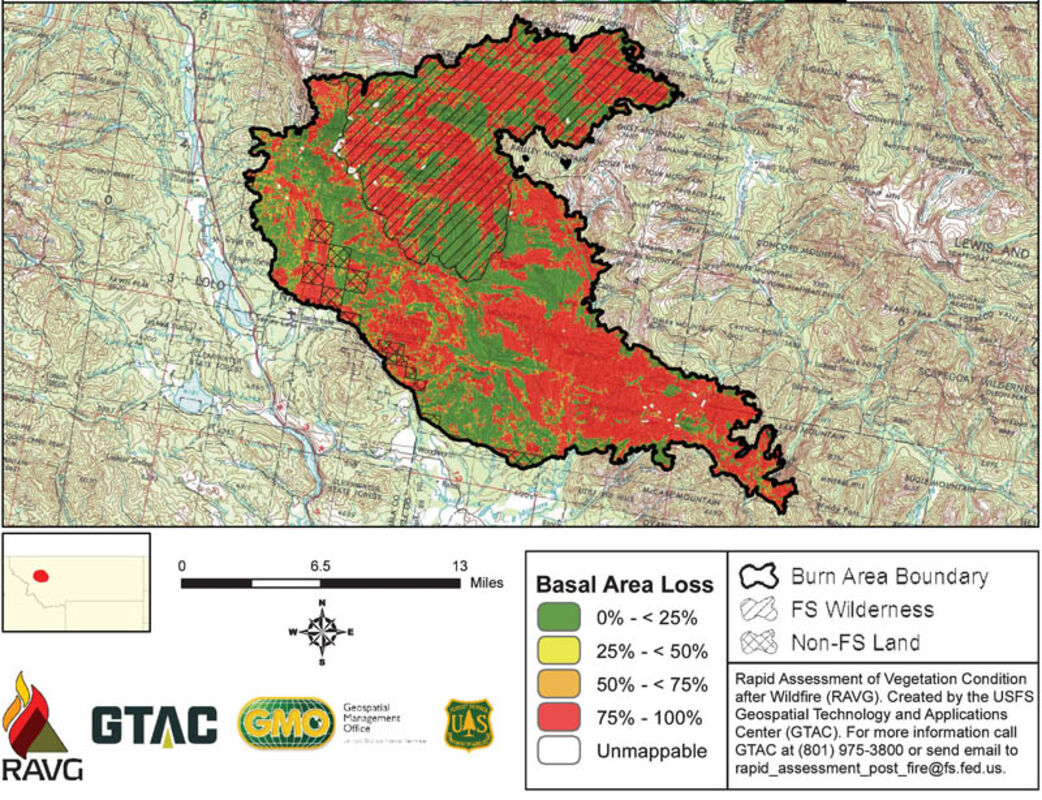
Basal area lost reflects the amount of tree mortality from the Rice Ridge Fire. In many areas, crown fire moved quickly through an area, causing the trees to burn but leaving the soil relatively intact, including the root mass and forest duff materials. Because of this, regardless of tree mortality, the forest floor will start to green up in the next few years in areas with low and moderate soil burn severity.
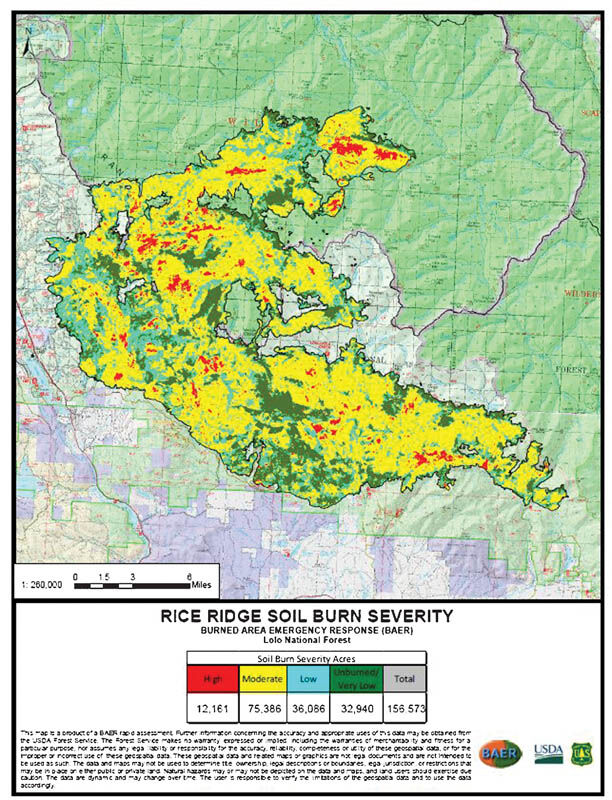
Soil burn severity is based on changes to root composition and soil structure, changes in ground cover, ash color and depth, and hydrophobicity (water repellency). The map is created using satellites and the burned area reflectance classification. That becomes the soil burn severity when it is field verified. The BAER team uses the Soil Severity Map to focus in on areas that have the highest concentrations of moderate (yellow) and high (red) severity. It is used to look at the burn severity in the drainage and assess the size of the culverts that will need to support the added run off and allow for fish passage since all the major drainages are either occupied or critical bull trout habitat.
by Andi Bourne
Pathfinder
SEELEY LAKE – The Rice Ridge 20-person Burned Area Emergency Response (BAER) team finished their assessment of the Rice Ridge Fire Oct. 20. In 11 days they were able to create a plan to mitigate threats to the public, forest infrastructure and native plants and animals. Implementation has already begun in critical areas of the fire and will continue through next October.
The BAER team addresses the effects of the fires including the potential for flooding and erosion, failure of culverts and roads, weed spread and risks to adjacent lands. The team includes soil scientists, hydrologist, botanists, road engineers and other specialists from all over the United States to assess the values at risk to the forestlands due to a wildland fire. From this assessment they come up with a recommended list of projects to mitigate the identified risks.
"BAER teams address the burned area emergency," said Claire Campbell, Lolo National Forest Soil Scientist and BAER team member. "We have very strict timelines and we bring in a lot of people to help us pound the ground and see what we need to see. We also have to make some assumptions associated with this stuff because you can't see everything."
BAER assessments must be conducted on all fires more than 500 acres.
BAER strategizes its response first with natural recovery, second using administrative closures and then finally doing BAER treatments to stabilize the emergency and protect the values at risk.
Values assessed by the BAER team include human life and safety, road and trail systems, hydrologic function, improving soil productivity, noxious weeds and cultural resources. There were no cultural resources at risk in the front country in the area of the Rice Ridge.
There are 25 miles of hazard tree work on trails and at trailheads in the Seeley Lake Ranger District (SLRD) and 17 miles proposed on the Spotted Bear Ranger District on the Flathead National Forest.
"We are focusing on areas where either the public or Forest Service personnel are congregated for significant amounts of times like campsites," said Campbell.
There are 518 miles of road within the Rice Ridge Fire perimeter and 180 miles of roads that are open to the public within the fire. There are six locations where the BAER team proposed pulling culverts on closed roads. Campbell said this will not change the travel management plan long term.
Campbell said there are concerns about three culverts on the Dunham Creek Road on the way to Lodgepole Trailhead. The culverts are undersized for the watershed conditions expected to come through the area.
"We know those are three locations that we are worried about because it is occupied bull trout habitat [and it was a stand-replacing crown fire]," said Campbell. "But we don't have the implementation plan yet."
The entire 160,000+ acre fire is either occupied or critical bull trout habitat.
"That was one of the big drivers for a lot of work we were looking at especially for the road and culvert kinds of work," said Campbell.
The District was able to get some initial BAER funding for 24 miles of road drainage maintenance to clean out culvert inlets and mitigate other drainage issues. This also included posting signs that say "Entering Burned Area."
Campbell said that the fire burned off the reflectivity on the gate signs.
"We are working on replacing that as soon as possible but if the public is out there in dawn and dusk the gates may be harder to see," said Campbell.
There are 130 miles of summer trails, a third of the trails on the Seeley Lake Ranger District, within the fire perimeter. Of the 130 miles of trails affected, 69 miles of trail were in areas with high or moderate soil burn severity.
The BAER group requested funding for: spot retread which would include fixing slumps and filling holes; extended retread in areas where the trail has completely slumped, has a soft bed or shoulder or is no longer discernible; erosion control which includes installation and/or repair of waterbars, drain dips, check dams and culverts; and hazard tree removal in areas where trail crews will be working or camping for extended periods of time.
Some of the more popular trails that will need a lot of work are the Monture-Hahn Trail #27, Falls-Canyon Trail #16, Center Ridge Trail #246, Dunham Creek Trail #400 and Art Jukala (Shanley Ridge) Trail #401.
Impacts to Morrell Falls Trail #30, Pyramid Pass Trail #416, Hobnail Tom (North Fork) Trail #32, and Lodgepole Trail #13 were fairly light. Trail crewmembers from the Seeley Lake Ranger District, Rocky Mountain Ranger District on the Helena-Lewis and Clark National Forest and the Spotted Bear Ranger District on the Flathead National Forest completed most of the work this fall. SLRD Trails Manager Katie Knotek said she expects the trails will likely need additional work in the spring but "We brought these extra crew members in to increase the amount of work we could get done this fall."
Another proposed treatment is noxious weed control. There are 4,000 acres of known weeds within the fire perimeter that were proposed for BAER treatment. This includes treating open roads, trails, outfitter camps, dozer lines and log landings.
"The weeds are a threat to native plant communities so they become a BAER issue," said Campbell.
All BAER treatments must be implemented within one year of fire containment. This is to ensure emergency stabilization occurs before the first damaging weather event.
The regional forester typically approves the proposed actions. However, when the treatment budget is greater than $500,000, the plan must be sent to Washington D.C. for approval. The funding request for the Rice Ridge Fire was sent to Washington D.C.
"The BAER request is higher than normal because the burned area is so huge. There are a ton of values at risk," said Campbell.
Bridges cannot be replaced using BAER funding. While it is an access issue, it is not viewed as an emergency action. The BAER response for an area with a burned out bridge with no other access would be an administrative closure until funding was available to replace the bridge.
The SLRD lost one trail bridge on the Monture Trail at Wedge Creek along with several puncheons, wooden walkways used to cross bogs and/or small streams. The new puncheon put in on the South Morrell Trail #30.1 was among those lost.
"We will look for funding opportunities to replace these structures, both the materials and the cost to construct them," wrote Knotek.
BAER also does not deal with reforestation or salvage logging.
"BAER is specifically for an emergency action, to stabilize the emergency created by the effects of the fire; to keep you from losing a road or have hazard trees fall all over a trailhead," said Campbell. "These other actions are to improve the forest condition ecologically but they are not emergency situations."
One of the things emphasized to the BAER Team by Seeley Lake District Ranger Rachel Feigley was that the BAER works was not supposed to influence travel management for this year.
"We understand that this fire really hurt the economy of Seeley Lake. We don't want to make it worse through the BAER efforts," said Campbell. "We are trying to work with hunters [and] outfitters to keep the area open for as long as possible. Nothing on groomed [snowmobile] trails will be influenced within the fire area [due to the BAER efforts]."
Campbell continued, "Fire is a part of the natural ecosystems. I can't help but think that the fires of 1910 were 107 years ago and these are 100-year fire regimes. We are right on time says Mother Nature."


Reader Comments(0)