
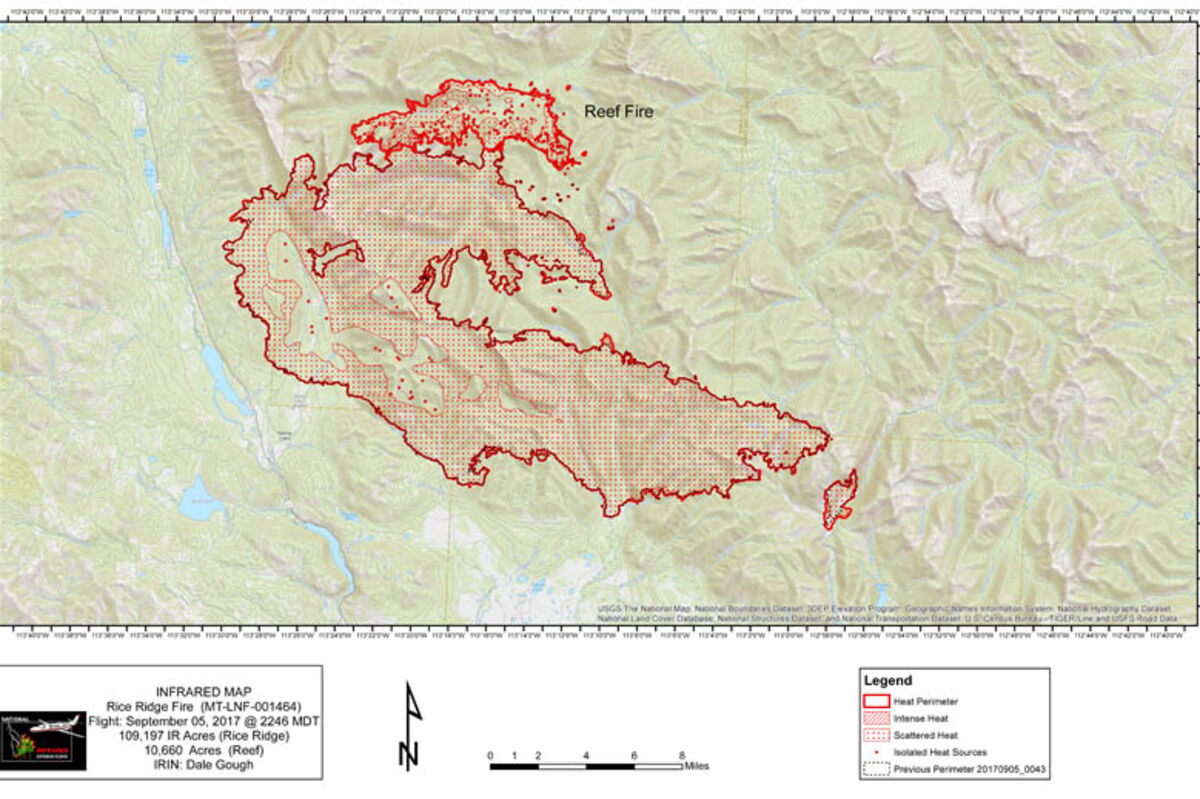
Rice Ridge Fire Map
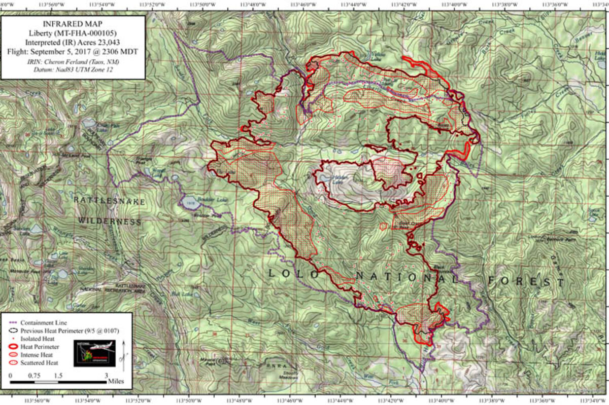
Liberty Fire Map for Wednesday
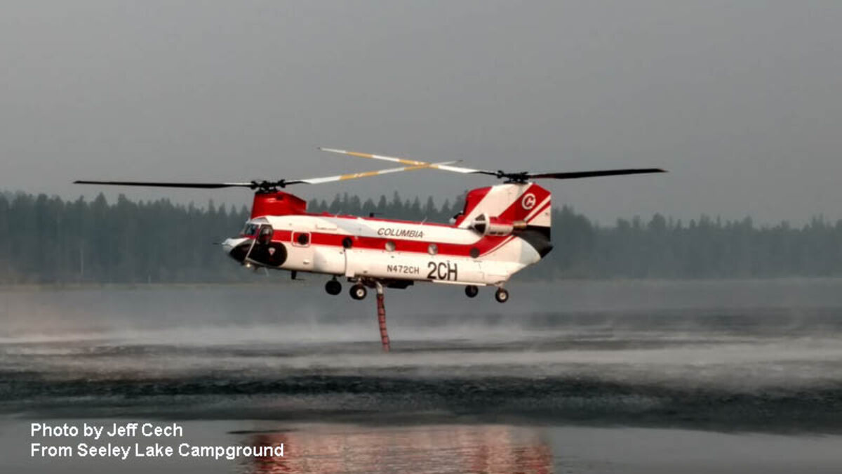
The Chinook pulling water out of Seeley Lake as seen from Seeley Lake Campground
ANNOUNCEMENT: Due to extreme fire conditions, The Nature Conservancy (TNC) lands in western Montana are temporarily closed to all public access until conditions improve. TNC joins private timber companies, Weyerhaeuser and Stimson Lumber Company, in closing their western Montana lands to all public recreation, due to extreme fire danger.
RICE RIDGE FIRE MORNING UPDATE: The Rice Ridge Fire grew to more than 109,000 acres and has merged with the 10,000 acre Reef Fire to the north east. The new reported acreage is 119,857 acres. The fire is 2% contained, has cost $31.6 million to date and now has 686 personnel assigned to the fire.
YESTERDAY: Yesterday the inversion lifted enough that by early afternoon helicopters were able to deliver water along the northwest side of the fire, aiding the Flathead Hotshots and several dozers that were constructing fire line in that area. Crews were able to continue line improvement east of the town of Seeley Lake. Particular attention in that area was to seal the fire line around several slopovers from previous days and continue to work in the Morrell Creek area where the fire line crosses the drainage. Fuels are so dry that a normally wet spruce bog in the bottom of the Morrell Creek drainage is continuing to burn, making it more complicated to extinguish fire in the heavy downfall located there. An isolated cabin just east of Seeley Lake but inside the fire area was saved after firefighters happened to arrive at the same time that a burning tree came down on the roof of the cabin. Heavy equipment continued to work on improving fire line south along Forest Road 477 between Seeley Lake and Monture. Mop up continued in the Monture Cabin area and sprinkler systems were installed around 1/3 of the cabins in the Coopers Lake area. Over 100 people attended a public meeting in Ovando last night. Upon further review, the fire immediately east of the main fire in the North Fork of the Blackfoot River (directly north of the North Fork Trailhead) may have been a holdover lightning fire rather than a spot fire from the main fire. Night operations continued to patrol in the Seeley Lake and Monture areas.
TODAY: Higher temperatures and lower relative humidity, in combination with a highly unstable air mass over the fire area is expected to result in increased fire activity later in the afternoon, especially on the south side of the fire.
Firefighters will continue to hold, mop up and improve line on the Seeley Lake side of the fire, including the use of heavy equipment to extend fire line and construct sheltered fuel breaks to the southeast. Heavy equipment will be used to remove some of the downed trees in the spruce bog in the Morrell Creek drainage so firefighters will be able to do a better job of mop up in that location. Work will begin with heavy equipment on indirect fire line construction east from Monture. Structure protection will continue around Coopers Lake with structure assessment in the Upper Blackfoot Ranch community. Firefighters from Seeley Lake Ranger District will be flown in to wrap the Carmichael Cabin in the upper North Fork of the Blackfoot River near McDonnell Meadow northeast of the fire. Firefighters will coordinate operations with the Park Creek fire to the east as these fires grow closer together. Preliminary structure assessment will begin around the Placid Lake area west of Seeley Lake in order to be prepared ahead of time in the event that the Liberty fire moves towards that area.
EVACS AND WARNINGS:
Powell County evacuation order: includes the Monture Cabin area and the Coopers Lake area.
Powell County evacuation warning: includes all other areas of Powell County north of Highway 200 between the Missoula County line on the west and the Lewis and Clark County line on the east.
Missoula County evacuation orders and warnings:
At 5:35 pm on Monday, Evacuation Zone 1 in Seeley Lake was downgraded from an Evacuation Order to an Evacuation Warning, allowing residents in that area to return to their homes for the first time since August 28th. This change affected approximately 429 properties.
All other Orders and Warnings in Missoula County remain in effect.
Missoula County residents can receive emergency notifications of critical alerts via their choice of text, phone and/or email by signing up for Smart911 at https://www.smart911.com/. Residents in Powell County can download CodeRED to their mobile devices to receive critical information notifications, available through the Sheriff's website.
Evacuation Shelters: Anyone seeking shelter may call the Red Cross of Montana at 1-800-272-6668.
Seeley Lake: Camp Paxson at 4200 Boy Scout Road.
Ovando: Ovando Elementary School Gymnasium at 108 Birch Street.
Missoula: University Congregation Church, 405 University Avenue
FIRE INFO LOCATIONS: Staffed fire information is available in Seeley Lake at Cory's Valley Market (from 8 am to 8 pm). Non-staffed locations are at the Post Office and Rovero's Ace Hardware in Seeley Lake, the Sinclair Service Station in Greenough, at the Intersection of MT200 and MT209 west of Ovando, and the Blackfoot Mercantile in Ovando.
Firewise: For information on how to improve the chances of your homes and structures surviving a wildfire, visit the Firewise website at http://www.Firewise.org.
Evacuation/Closure Information: Evacuations and road closures are based upon the need to provide for safety of the public and firefighters, current fire behavior, forecasted weather, and planned suppression operations. Fire officials, Missoula and Powell County Sheriff's Offices, and Montana Department of Transportation will evaluate the evacuation and road closures daily. The Incident Commander, Missoula County Rural Fire Chief, and the Missoula and Powell County Sheriffs appreciate your patience and will work hard to get you back into your homes as soon as it is safe to do so. Go to the Missoula County Sheriff's Facebook page or, in Powell County, call 406-396-1386 for the most current information.
Drones and TFR: There is a Temporary Flight Restriction (TFR) for the Rice Ridge Fire. The restriction includes "drones" or unmanned aerial vehicles. If drones are detected, air operations stop. "If you fly, we can't! If you see a drone in the fire area, including the evacuation areas, report it immediately to 406-813-0527. Please provide your name, phone number, location and time you observed the drone. Your cooperation is needed to insure the safety of our pilots.
Stage II Fire Restrictions are in effect for Missoula and Powell Counties and across the Lolo and Flathead National Forests with the exception of the Bob Marshall Wilderness which is in Stage 1. However, many areas in the wilderness are closed due to the fire. Additional information is on Inciweb and the Lolo and Flathead National Forest websites.
Closures: Multiple closures related to Rice Ridge Fire suppression efforts are in effect for public lands managed by the Lolo and Flathead National Forests, Bureau of Land Management, Montana DNRC, and Montana Fish, Wildlife and Parks.
The fire is under the jurisdiction of the Lolo National Forest and the Montana Department of Natural Resources (MTDNRC). Montana National Guard soldiers are providing assistance to the Missoula and Powell County Sheriffs' offices in road closures and evacuation programs.


Reader Comments(0)